Case study Smart Map for travellers in and around Maastricht
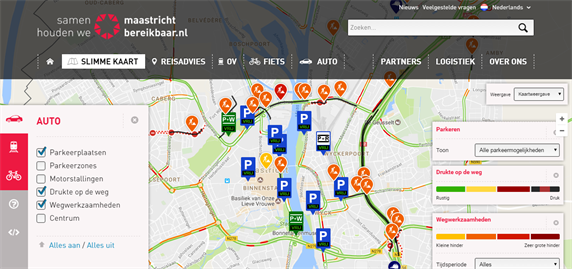
The Smart Map is an online map to be deployed as a source of better information for commuters and visitors in Maastricht, during the roadworks on the A2 motorway at Maastricht. The Smart Map is a Google Maps-based application, accessible via maastrichtbereikbaar.nl. Using the Smart Map, travellers can select the best travel option, prior to departure.
By simply clicking on the various options, the Smart Map reveals the possibilities for travel by car, public transport and bicycle. The map also shows current travel information that the user can turn on or off at will. Below is an overview of this information for car, public transport and bicycle:
| Car | Public transport | Bicycle |
|---|---|---|
| Parking spaces | Stations | Bicycle sheds |
| Parking zones | Work | Bicycle-free zones |
| Motorbike parking | Public transport bike | |
| Road congestion | Roadworks | |
| Roadworks | ||
| City centre area |
An additional feature of the Smart Map is that it can be integrated into your own website, including your own preferences and zoom area. This can for example help individual companies inform their employees (or other target groups) via their own website or intranet site.
Background and aim
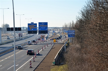
Maastricht Bereikbaar was set up to communicate more traffic information and mobility advice to road users during the reconstruction of the A2 through Maastricht. The busy A2 used to run right through the city, which caused a lot of inconvenience. For this reason, the construction of the Koning Willem-Alexander Tunnel began in 2010. This was completed at the end of 2016.
The tunnel ensures that the A2 between De Geusselt and the Europaplein junction no longer forms a physical barrier in the city. This improves Maastricht's accessibility and liveability, and also traffic flow on the A2.
For Maastricht Bereikbaar (a partnership between the authorities, the business community and mobility providers in and around Maastricht) the construction of the Koning Willem-Alexander Tunnel and the expected disruption was the reason to take various traffic and mobility measures.
One of them was the Smart Map. Providing commuters and visitors with up-to-date, personal pre-trip information makes them better prepared for travel and enables them to make smart choices to reach Maastricht. The Smart Map now includes city-wide roadworks and major regional roads around Maastricht. The tool is now a fixed element in traffic advice for a variety of roadworks and infrastructure projects.
Scope and effect
Every month, more than 13,000 website visitors consult the Smart Map This applies to both 2015 and 2016 (in 2014 this figure was still 76% lower). The Smart Map has been used more and more actively as a communication tool and in campaigns as a result of the increase in the number of roadworks. The options offered by the map have also been further expanded over the past two years, and the visibility of the website has been improved.
Points for attention
- Start small and develop further: the Smart Map started small and the number of features is still being expanded. This enabled the Smart Map to be launched quickly and expanded to meet the needs of users. The map is still being updated to keep pace with developments in the market. Development continues: soon users will be able to save their personal preferences.
- National data developments: in addition to the accessibility targets, the aim has always been to directly implement various data developments from the Optimising Use programme in the Smart Map. This includes up-to-date data in the case of roadworks and, more recently, up-to-date parking data, both of which have become available via an open data platform.
- Travellers' needs: continue to see things from the user's point of view. They always want to be able to choose which information they see or not. The map has various layers enabling each user to customise it. This means a greater chance that users will return to the Smart Map compared with a more general map.
- Keep development simple: no specialist company was used to build the Smart Map. A good web designer can produce such a map with the right data sources and the map itself as the main input.
- Connect with Smart Mobility developments. At present, Maastricht Bereikbaar is looking at how the current developments in Talking Traffic can also be implemented in the next version of the Smart Map.
Can the measure be deployed more broadly?
The aim has always been to develop the Smart Map so that it can be used more widely than just for Maastricht and its surrounding area. The principle is in place and other regions can now make use of it easily. What is important in this respect is that Maastricht Bereikbaar has adopted the national Smart Mobility innovations and has made the data sources on the Smart Map available for everyone via the national open data standards. The website itself was developed by a ‘normal’ web builder, and as such, building a similar website elsewhere should not represent an obstacle.
See also